Hiking Wheeler Peak…

Note: You may have read this post way too early. WordPress hiccuped and I couldn’t fix it. But here it is, in the intended order of posting.

We talked to a local who said that if we started our hike early, we ought to miss the storm that was forecast at Wheeler Peak so Chris, Steve, and I were out the door by 5:00 AM on our last vacation day. Lorna opted to stay back with the kids on their last day in Red River. She and her mom took them on a 4-wheel excursion up the mountain.

We parked the car at Taos Ski Valley (altitude 9439′) and started up the Bull of the Woods trail. This is longer, slightly easier, scenic route to the top, but it’s uphill all the way. It is 2.1 miles to this meadow.

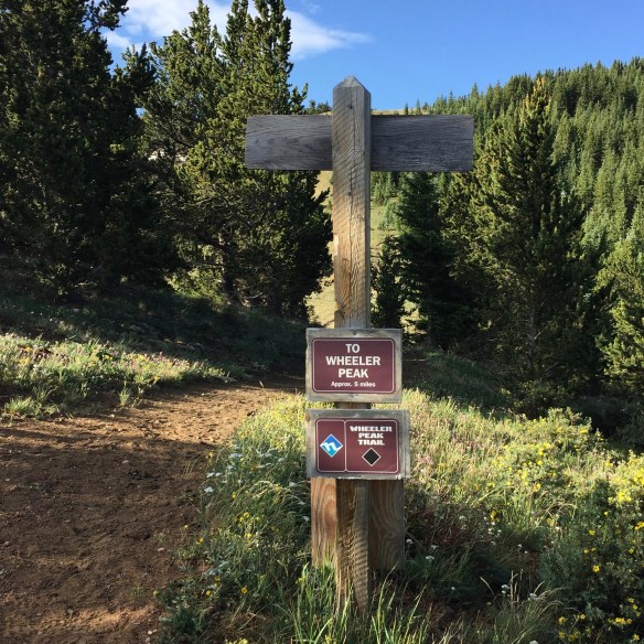
We still have 5 1/2 miles to go to reach the peak. Oh my. This sign got my attention. If you ski, you know that a black diamond means ‘expert’. It may not mean that for this hike, but it wouldn’t surprise me at all.

IMG_0702

Some parts were only a little uphill, more were really uphill, and there were a few disheartening spots where we went downhill and then had to climb back up. Deep sighs all round.

We walked across snow a few times…

Honestly, our lungs were killing us. As we got higher, we stopped to breathe every 100 steps.

IMG_0739

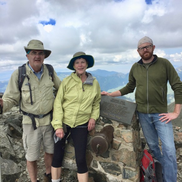
You reach the 2nd highest point before the you get to the actual peak. And then you hike down a while before turning back up. It was harder than it looked like it would be but we did it. Wheeler Peak, altitude 13, 159′

IMG_0752

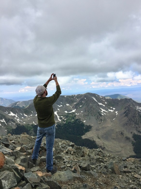
The views were amazing!

This slideshow requires JavaScript.

IMG_0764

This is Chris standing way closer to the edge than Lorna would have been able to tolerate…

IMG_0757

We took the short, steep way down. The first part were switchbacks over a huge granite talus field. I was happy to have on knee braces and to have a real trekking pole because this was the scariest part of the whole hike. No photos, I was focused on not falling.

The last part of this trail intersects with the downhill part of the Williams Lake trail that we had hiked earlier in the week. We went back to the Bavarian Restaurant to celebrate reaching the peak and hiking 11 1/2 miles with more Andechs beer. As we sat there, the rain finally came. Life is good :-).


More Mountain Hiking!

Steve, Chris, Lorna, and I had planned to hike up Wheeler Peak (the highest spot in New Mexico) 2 days before the end of our trip. Unfortunately, the weather changed and thunderstorms were in the forecast. We could have maybe stood being wet, but not being fried by lightening. Instead, Steve and I hiked the Pioneer trail in Red River.

Pioneer Trail – Easy – 3 miles one way: Next to the Ski Area, this trail built by miners in the gold rush days, begins where Pioneer Road ends. You just might find an old claim as you explore this one.

OK. This is another one of those trails that is all uphill until you’ve had enough and turn around. Who decides what an easy trail is in New Mexico? But it was pretty, and it didn’t rain.

But it had rained the night before. The farther we went, the more water we found. There were 4 places where we either had to wade across or find another route.

In all cases, we opted to go around. Others had gone before us so it was easy to find a way across the streams and get back to the path.

People in 4-wheelers passed us going and coming.

The farther we went, the wetter the path got until it was more stream than path.

We gave up 3 1/2 miles in. Downhill was going to be hard without poles so Steve pulled out his trusty Swiss Army knife and cut us each one. I was both impressed and thankful.

It was a very nice hike and we were happy to have done it, but sorry to not have hiked Wheeler Peak. More on that next post.


Mountain hiking…

Our home in Sherman, TX, is 735′ feet above sea level. Red River is at 8671′. We were nearly 8000′ feet higher than normal and my lungs knew it. After taking 2 days to acclimate, we went on our first hike to Williams Lake. The trail begins at the Taos Ski Valley and is nearly 4 miles round trip. You start at 10,191′ and climb about 1000′ to the lake.

WiliamsLake--15

This is supposed to be an easy hike and, in comparison to the next 2, it was. But walking uphill at that altitude is hard work! The kids were not mentally prepared and there was (gasp) a fair bit of whining.

Lorna took the Tula (a kid carrier) and she (mostly) and Chris (some) carried Bear most of the way.

WiliamsLake--26

Bear is tall and weighs 40 lbs. I’m not sure how they did it.

WiliamsLake--37

Jack embraced the challenge about a mile in.

WiliamsLake--80

I always wonder, when I’m hiking, why I am doing it. My lungs were not happy when going uphill and my knees are not happy when I’m going downhill. What is the point? Well, one reason I hike is for the scenery:

The other reason I go on strenuous hikes is to prove that I can still do it!

IMG_0594

There is a Bavarian Restaurant at the end of this hike that serves traditional German food and Andechs beer on tap. Beer was the adult reward, the kids had sausage and lemonade :-).

IMG_0469


Hiking at Kampenwand…

We took the S-Bahn (smaller train) to Kampenwand. It is a ski resort in the winter and a hiking spot in summer. There is a gondola to take you up the side of the mountain.

OLYMPUS DIGITAL CAMERA

OLYMPUS DIGITAL CAMERA

You can hike to the top of the rocks, but we didn’t. We did hike to the Biergarten that is very near there.

OLYMPUS DIGITAL CAMERA

It wasn’t a hard hike.

IMG_4324

Along the way we watched para gliders taking off. There were lots of them flying around.

OLYMPUS DIGITAL CAMERA

There were cows! Actually, there are a lot of cows in Bavaria and they look somehow different from the cows I’m used to seeing.

OLYMPUS DIGITAL CAMERA

There is a small church…

OLYMPUS DIGITAL CAMERA

From this spot you can see another trail that takes you to a different high spot that overlooks the valley below. We decided to hike down and then up that little trail that you see in the next photo.

OLYMPUS DIGITAL CAMERA

Steve and I are still working on perfecting our selfies :-).

IMG_7565

HHKB4614

OLYMPUS DIGITAL CAMERA

There are several places to hike in Bavaria and I’m so glad that we are on this trip!

DWRG8016

From the Big Island of Hawaii…

We spent the day hiking, looking for birds and looking at nature. It was fun and it’s late so I’m not writing much, just sharing photos :-).

beckygoldsmith-BigIsland-1-10

We started with the Pu’u O’o Trail hike, which starts off of the Saddle Road. It’s not a long hike, lots of stopping for photos and looking for birds, and taking photos of people (Steve and Keith) looking for birds.

Of the nearly 200 photos that I took today, only a few turned out well. I’m still working on manual focus, aperture, shutter speed, and ISO. Maybe, by the end of my 52 Week Photo Challenge class, I’ll be much better. As it is, I’m happy with the photos that did turn out well and the rest are gone!

beckygoldsmith-BigIsland-1-14

beckygoldsmith-BigIsland-1-41

This next one cracks me up… who is looking at what?

beckygoldsmith-BigIsland-1-52In the afternoon (after lunch at Sompat’s Thai in Hilo) we went to Volcano National Park and did the Pu’u Hulu Hulu trail this afternoon.

beckygoldsmith-BigIsland-1-23

That’s Amanda, sitting next to a broken lava dome.

beckygoldsmith-BigIsland-1-29

This is a spent Ohi’a Lehua blossom. I’ll have more of these later on.beckygoldsmith-BigIsland-1-34

Amanda got a nice picture of me—many thanks to Amanda! I don’t look as bad in the hat as I imagined that I did!

DSC_0006

This is a branch from an Ohi’a Lehua tree. The look of the tree changes depending on where they are. I am doing my best to take interesting pictures that are in focus and not over or under exposed, manually. I love it when it works!

beckygoldsmith-BigIsland-1-139

We saw several rainbows today and this one, on the way back to our rental house, made us stop to take pictures. The ends of the rainbow were both in the crater. So cool!

beckygoldsmith-BigIsland-1-45

I hope to post more photos tomorrow. I hope that you are enjoying your life right now as much as we are :-).